
 Pocket Profile Art Loeb Trail Elevation Profile Map


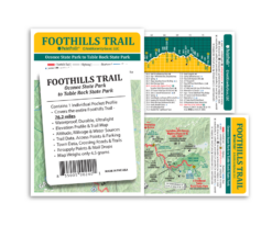
Pocket Profile Foothills Trail Elevation Profile Map


$4.95
In stock
Weight: 0.14 oz.
The entire 76.2 miles of the Foothills Trail at a glance! Weighing in at just 4 grams, this water-proof, durable map features a Foothills Trail map on one side and an elevation profile with altitudes and trail data/information on the other. Trail data information includes trail mileage, access points & parking, campsites, water sources, town data, crossing roads, resupply points, mail drops and more. All the information day-hikers and backpackers need to explore this great trail in one convenient indestructible tool! AntiGravityGear’s long trail Pocket Profile Maps were listed in the April 2012 Backpacker Magazine Spring Gear Guide under the heading “The Ten Essentials”! A serious tool for trail use and hike planning.
Features:
- Printed on Durable Waterproof Plastic
- Full Color
- Foothills Trail Elevation Profile (side 1)
- Foothills Trail Map (side 2)
Specifications:
- Dimensions: 3.9 in W x 17 in L
- Weight: 0.14 oz/4 g each
Yes! Our US supplier abides by the 4 R’s of environmental stewardship: Recycle, Reuse, Respect, & Reduce.
Recycle & Reuse
Waste linked to the synthetic paper production
- The production waste is regranulated and recycled in our production processes.
- Production scrap that cannot be reused in the production process is collected by a recycling company to be reprocessed as raw materials for other plastic items.
Waste produced by printing processes
Minimizing End-User Waste
Respect
- All production sites comply with ISO 14001 environmental standards.
- Have their own water treatment plants to handle the water used in their processes. Waste water is therefore already clean when it leaves the production sites.
- The manufacturing process does not use ozone-depleting substances such as CFCs.
- The manufacturing process does not include any dangerous or polluting components.
Health and Safety
- In addition to complying with the ISO 14001 EMS standards, our supplier has taken the following health and safety initiatives:
- Components are fully compliant with the following legislation dealing with heavy metals:
- The 1994 standard of the Coalition of Northeastern Governors’ Model Toxic (CONEG).
- Part 3 of the 10988 European EN71 standard stipulating upper limits for toys and film coatings.
- The requirements set out in the EC directive 94/62/EC relating to packaging waste.
- Does not contain phthalate, chlorine, or other halogens.
- When incinerated under the right conditions, the paper is non-toxic and does not produce dioxins or other highly toxic materials.
Reduce
- It has no impact on forest resources.
- The manufacturing process uses five times less water that traditional paper production, thus preserving water resources.
- It has a long service life in its applications (maps, tags and manuals, for example), thus reducing the need for source materials.
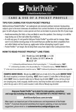
The AntiGravityGear Pocket Profiles™ are waterproof, rub resistant and tear resistant. Backpacking subjects gear to the most strenuous of conditions that will test the limits of any well made piece of gear. And so, as with all backpacking gear, there is some special care that can be taken to preserve the life of your Pocket Profile™.
- Your Pocket Profile™ is rub resistant, meaning the ink is quite durable and will not rub off easily. And while your profile is in no way fragile, abuse can test the limits of the rub resistance. The folds are likely to wear the quickest. Avoid overworking the folds. One strategy is to roll the map and put it in your accessory pocket on your pack rather than folding it.
- As with any gear, it’s not good to fold your Pocket Profile™ up while wet for storage. After it has gotten good and wet, give it a good dry off before folding and stowing it. If your Pocket Profile™ was accidentally allowed to dry completely from wet while folded, and is frozen together, run it under water for a while and slowly and gently work it apart.
- Your Pocket Profile™ is tear resistant, meaning it’s difficult to tear, but not impossible. Keep it away from sharp objects that could puncture it in your pack.
A little care and good common sense will go a long way to preserving the life of your Pocket Profile™.
 The Pocket Profile™ in the photo to the left has been soaking in this Nalgene bottle for 6 months. It has been taken out and crumpled up and put back in several times. Basically, we’re abusing it. While it definitely does not look as beautiful as it did when it was brand new, it is holding it’s own. It’s still quite readable, and would definitely still get us down the trail.
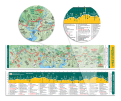
The AGG TEC™ reference number located between mile markers above the elevation profile is the measure of Total Elevation Change per segment. These are also commonly referred to is PUDs or MUDs (Pointless Ups & Downs or Mindless Ups & Downs). This rating is meant to give you an idea of how TEChnical the terrain ahead of you will be.
For instance: If, during the course of a 3 mile segment, you climb 1000 feet and descend 500 feet, the AGG TEC™ number for that 3 mile segment would be 1500. This number, when compared to the elevation profile, can give you an idea of how much elevation change is ahead and whether it is likely to be more uphill or downhill or a mixture of both ups and downs.
At the top, in the blue bar on the elevation side of each profile, is an AGG TEC™ reference number for the entire section of the trail that the map covers.
This is what the TEC™ numbers look like. They are the grey numbers in between mile markers:

You may also like…


